 |
|||||||||||||||||||||||||||||||||||||||||||
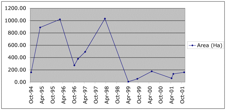
| The timeline (above) displays the area of water hyacinth, in hectares, observed on the surface of Mwanza Gulf, Tanzania on a series of dates. The table to the right contains the same data in text format. The values can be copied and pasted into the application of your choice for analysis. |
|
||||||||||||||||||||||||||||||||||||||||||
 |
|||||||||||||||||||||||||||||||||||||||||||
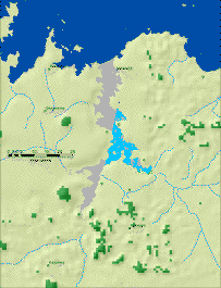
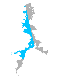
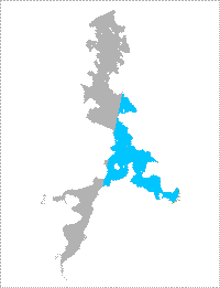
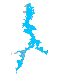
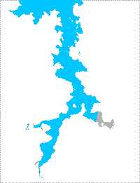
| The classified image, to the left, of Mwanza Gulf has been superimposed on a shaded elevation matrix (from GTOPO30). Population points and hydrography (from the Digital Chart of the World) and the main body of Lake Victoria (in dark blue, from the USGS report) were added to provide locational context. This image, and the twelve below, are linked to high-resolution images that can be panned and zoomed in and out so that you can view details of the water hyacinth's location on particular dates. The legend below applies to area inside Mwanza Gulf for all thirteen images. | |||||||||||||||||||||||||||||||||||||||||||
| Date: 1994-10-08 Area WH (Ha): 157.59 % visible: 30.06 |
|||||||||||||||||||||||||||||||||||||||||||
 |
|||||||||||||||||||||||||||||||||||||||||||
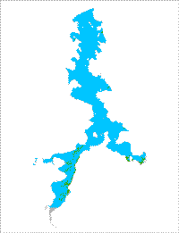
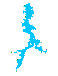
| Visible water in Mwanza Gulf on date | |||||||||||||||||||||||||||||||||||||||||||
| Visible water hyacinth on date | |||||||||||||||||||||||||||||||||||||||||||
| Obscured on date (clouds, outside imagery boundary) | |||||||||||||||||||||||||||||||||||||||||||
 |
 |
 |
 |
||||||||||||||||||||||||||||||||||||||||
| Date: 1995-03-08 Area WH: 887.4 % visible: 98.94 |
Date: 1996-02-15 Area WH: 1019.00 % visible: 97.54 |
Date: 1996-10-31 Area WH: 271 % visible: 97.4 |
Date: 1996-12-06 Area WH: 378 % visible: 99.96 |
||||||||||||||||||||||||||||||||||||||||
 |
 |
 |
 |
||||||||||||||||||||||||||||||||||||||||
| Date: 1997-04-19 Area WH: 491.04 % visible: 100 |
Date: 1998-03-04 Area WH: 1030.25 % visible: 100 |
Date: 1999-04-12 Area WH: 5.34 % visible: 46.25 |
Date: 1999-09-12 Area WH: 52.74 % visible: 33.23 |
||||||||||||||||||||||||||||||||||||||||
 |
 |
 |
 |
||||||||||||||||||||||||||||||||||||||||
| Date: 2000-05-16 Area WH: 174.69 % visible: 99.99 |
Date: 2001-04-05 Area WH: 62.25 % visible: 100 |
Date: 2001-05-12 Area WH: 132.84 % visible: 87.07 |
Date: 2001-11-27 Area WH: 159.12 % visible: 95.15 |
||||||||||||||||||||||||||||||||||||||||